World's Unexplained Mystery: Stonehenge
 |
| Images Wikipedia |
Stonehenge is a prehistoric monument in Wiltshire,
England, about 2 miles (3.2 km) west of Amesbury and 8
miles (13 km) north of Salisbury.
One of the most famous sites in the world, Stonehenge is the remains of a ring
of standing stones set within earthworks. It is in the middle of the most
dense complex of Neolithic and Bronze Age monuments
in England, including several hundred burial mounds.
Archaeologists believe it was built anywhere from
3000 BC to 2000 BC. Radiocarbon dating in 2008 suggested that
the first stones were raised between 2400 and 2200 BC, whilst another
theory suggests that bluestones may have been raised at the site as early
as 3000 BC.
The surrounding circular earth bank and ditch, which
constitute the earliest phase of the monument, have been dated to about 3100
BC. The site and its surroundings were
added to the UNESCO's
list of World Heritage Sites in 1986 in a
co-listing with Avebury Henge. It is a national legally protected Scheduled Ancient Monument. Stonehenge
is owned by the Crown and managed by English
Heritage, while the surrounding land is owned by the National
Trust.
Archaeological evidence found by the Stonehenge Riverside Project in
2008 indicates that Stonehenge could have been a burial
ground from its earliest beginnings. The dating of cremated remains
found on the site indicate that deposits contain human bone from as early as
3000 BC, when the ditch and bank were first dug. Such deposits continued at
Stonehenge for at least another 500 years. The site is a place of
religious significance and pilgrimage in Neo-Druidry.
 |
| Images: worldalldetails.com |
Etymology
The Oxford English Dictionary cites Ælfric's 10th-century glossary, in
which henge-cliff is given the meaning "precipice", or
stone, thus the stanenges or Stanheng "not far from
Salisbury" recorded by 11th-century writers are "supported
stones". William Stukeley in 1740 notes,
"Pendulous rocks are now called henges in Yorkshire...I doubt not,
Stonehenge in Saxon signifies the hanging stones." Christopher Chippindale's Stonehenge
Complete gives the derivation of the name Stonehenge as coming
from the Old English words stān meaning
"stone", and either hencg meaning "hinge" (because
the stone lintels hinge on the upright stones) or hen(c)en meaning
"hang"
or "gallows"
or "instrument of torture". Like Stonehenge's trilithons,
medieval gallows consisted of two uprights with a lintel joining them, rather
than the inverted L-shape more familiar today.
The "henge" portion has given its name to a class
of monuments known as henges. Archaeologists define henges as earthworks consisting
of a circular banked enclosure with an internal ditch. As often happens in
archaeological terminology, this is a holdover from antiquarian usage,
and Stonehenge is not truly a henge site as its bank is inside its ditch.
Despite being contemporary with true Neolithic henges
and stone circles, Stonehenge is in many ways atypical –
for example, at over 7.3 metres (24 ft) tall, its extant trilithons
supporting lintels held in place with mortise
and tenon joints, make it unique.
 |
| Google Images: English Heritage |
Early history
Mike Parker Pearson, leader of the Stonehenge
Riverside Project based at Durrington
Walls, noted that Stonehenge appears to have been associated with burial
from the earliest period of its existence:
Stonehenge was a place of burial from its beginning to its
zenith in the mid third millennium B.C. The cremation burial dating to
Stonehenge's sarsen stones
phase is likely just one of many from this later period of the monument's use
and demonstrates that it was still very much a domain of the dead.
— Mike Parker Pearson
Stonehenge evolved in several construction phases spanning
at least 1,500 years. There is evidence of large-scale construction on and
around the monument that perhaps extends the landscape's time frame to 6,500
years. Dating and understanding the various phases of activity is complicated
by disturbance of the natural chalk by periglacial effects and animal burrowing, poor
quality early excavation records, and a lack of
accurate, scientifically verified dates. The modern phasing most generally
agreed to by archaeologists is detailed below. Features mentioned in the text
are numbered and shown on the plan, right.

Google Images: crystalinks.com
Before the monument
(8000 BC forward)
Archaeologists have found four, or possibly five,
large Mesolithic postholes (one
may have been a natural tree throw), which date to around 8000 BC, beneath the
nearby modern tourist car-park. These held pine posts around 0.75 metres
(2 ft 6 in) in diameter which were erected and eventually rotted in
situ. Three of the posts (and possibly four) were in an east-west alignment
which may have had ritual significance; no parallels are known from Britain
at the time but similar sites have been found in Scandinavia. Salisbury
Plain was then still wooded but 4,000 years later, during the earlier
Neolithic, people built a causewayed enclosure at Robin Hood's Ball and long barrow tombs
in the surrounding landscape. In approximately 3500 BC, a Stonehenge
Cursus was built 700 metres (2,300 ft) north of the site as the
first farmers began to clear the trees and develop the area.
Stonehenge 1 (ca.
3100 BC)
The first monument consisted of a circular bank and
ditch enclosure
made of Late Cretaceous (Santonian Age)
Seaford Chalk, (7
and 8), measuring about 110 metres (360 ft) in diameter, with a large
entrance to the north east and a smaller one to the south (14). It stood
in open grassland on
a slightly sloping spot. The builders placed the bones of deer and oxen in the bottom of
the ditch, as well as some worked flint tools. The
bones were considerably older than the antler picks used to dig the ditch, and
the people who buried them had looked after them for some time prior to burial.
The ditch was continuous but had been dug in sections, like the ditches of the
earlier causewayed enclosures in the area. The chalk dug from the ditch was
piled up to form the bank. This first stage is dated to around 3100 BC, after
which the ditch began to silt up naturally. Within the outer edge of the
enclosed area is a circle of 56 pits (13), each about a metre
(3 ft 3 in) in diameter, known as the Aubrey
holes after John Aubrey, the 17th -century antiquarian who
was thought to have first identified them. The pits may have contained standing
timbers creating a timber circle, although there is no excavated
evidence of them. A recent excavation has suggested that the Aubrey Holes may
have originally been used to erect a bluestone circle. If
this were the case, it would advance the earliest known stone structure at the
monument by some 500 years. A small outer bank beyond the ditch could also date
to this period.
In 2013 a team of archaeologists, led by Professor Mike Parker Pearson, excavated more than 50,000
cremated bones of 63 individuals buried at Stonehenge. These remains had
originally been buried individually in the Aubrey holes, exhumed during a
previous excavation conducted by William
Hawley in 1920, been considered unimportant by him, and subsequently
re-interred together in one hole, Aubrey Hole 7, in 1935. Physical and
chemical analysis of the remains has shown that the cremated were almost
equally men and women, and included some children. As there was evidence
of the underlying chalk beneath the graves being crushed by substantial weight,
the team concluded that the first bluestones brought from Wales were probably
used as grave markers. Radiocarbon dating of the remains has put
the date of the site 500 years earlier than previously estimated, to around
3,000 BCE.
 |
| Google Images: Archeology Archive |
Analysis of animal teeth found at nearby Durrington
Walls, thought to be the 'builders camp', suggests that as many as 4,000
people gathered at the site for the mid-winter and mid-summer festivals; the
evidence showed that the animals had been slaughtered around 9 months or 15
months after their spring birth. Strontium isotope
analysis of the animal teeth showed that some had travelled from as
far afield as the Scottish Highlands for the celebrations.
Stonehenge 2 (ca.
3000 BC)
Evidence of the second phase is no longer visible. The
number of postholes dating to the early 3rd millennium BC suggest that some
form of timber structure was built within the enclosure during this period.
Further standing timbers were placed at the northeast entrance, and a parallel
alignment of posts ran inwards from the southern entrance. The postholes are
smaller than the Aubrey Holes, being only around 0.4 metres (16 in) in diameter,
and are much less regularly spaced. The bank was purposely reduced in height
and the ditch continued to silt up. At least twenty-five of the Aubrey Holes
are known to have contained later, intrusive, cremation burials
dating to the two centuries after the monument's inception. It seems that
whatever the holes' initial function, it changed to become a funerary one
during Phase 2. Thirty further cremations were placed in the enclosure's ditch
and at other points within the monument, mostly in the eastern half. Stonehenge
is therefore interpreted as functioning as an enclosed cremation cemetery at
this time, the earliest known cremation cemetery in the British Isles.
Fragments of unburnt human bone have also been found in the ditch-fill. Dating
evidence is provided by the late Neolithic grooved
ware pottery that has been found in connection with the features from
this phase.
Stonehenge 3 I (ca.
2600 BC)
Archaeological excavation has indicated that around 2600 BC,
the builders abandoned timber in favour of stone and dug two concentric arrays
of holes (the Q and R Holes) in the centre of the site. These stone
sockets are only partly known (hence on present evidence are sometimes described
as forming ‘crescents’); however, they could be the remains of a double ring.
Again, there is little firm dating evidence for this phase. The holes held up
to 80 standing stones (shown blue on the plan), only 43 of which can be traced
today. The bluestones (some of which are made of dolerite, an
igneous rock), were thought for much of the 20th century to have been transported
by humans from the Preseli Hills, 150 miles (240 km) away in
modern-dayPembrokeshire in Wales. Another theory that has
recently gained support is that they were brought much nearer to the site
as glacial erratics by the Irish
Sea Glacier. Other
standing stones may well have been small sarsens (limestones), used later as
lintels. The stones, which weighed about four tons, consisted mostly of
spotted Ordovician dolerite but included examples of rhyolite, tuff and volcanic and calcareous ash;
in total around 20 different rock types are represented. Each monolith measures
around 2 metres (6.6 ft) in height, between 1 m and 1.5 m
(3.3–4.9 ft) wide and around 0.8 metres (2.6 ft) thick. What was to
become known as the Altar Stone (1), is almost certainly
derived from either Carmarthenshire or the Brecon
Beacons and may have stood as a single large monolith.
The north-eastern entrance was widened at this time, with
the result that it precisely matched the direction of the midsummer sunrise
and midwinter sunset of the period. This phase of
the monument was abandoned unfinished, however; the small standing stones were
apparently removed and the Q and R holes purposefully backfilled. Even so, the
monument appears to have eclipsed the site at Avebury in
importance towards the end of this phase.
The Heelstone (5), a Tertiary sandstone,
may also have been erected outside the north-eastern entrance during this
period. It cannot be accurately dated and may have been installed at any time
during phase 3. At first it was accompanied by a second stone, which is no
longer visible. Two, or possibly three, large portal
stones were set up just inside the north-eastern entrance, of which
only one, the fallen Slaughter Stone (4), 4.9 metres (16 ft) long,
now remains. Other features, loosely dated to phase 3, include the four Station
Stones (6), two of which stood atop mounds (2 and 3). The mounds
are known as "barrows" although they do not contain burials. Stonehenge
Avenue, (10), a parallel pair of ditches and banks leading 2 miles
(3.2 km) to the River Avon, was also added. Two ditches
similar to Heelstone Ditchcircling the Heelstone (which was by
then reduced to a single monolith) were later dug around the Station Stones.
Stonehenge 3 II (2600 BC to 2400 BC)
During the next major phase of activity, 30 enormous Oligocene-Miocene sarsen
stones (shown grey on the plan) were brought to the site. They may
have come from a quarry, around 25 miles (40 km) north of Stonehenge on
the Marlborough Downs, or they may have been
collected from a "litter" of sarsens on the chalk downs,
closer to hand. The stones were dressed and
fashioned with mortise and tenon joints before 30 were erected
as a 33 metres (108 ft) diameter circle of standing stones, with a ring of
30 lintel stones resting on top. The lintels were fitted to one another using
another woodworking method, the tongue
and groove joint. Each standing stone was around 4.1 metres
(13 ft) high, 2.1 metres (6 ft 11 in) wide and weighed
around 25 tons. Each had clearly been worked with the final visual effect in
mind; the orthostats widen slightly towards the top in order
that their perspective remains constant when viewed from the ground, while the
lintel stones curve slightly to continue the circular appearance of the earlier
monument. The inward-facing surfaces of the stones are smoother and more finely
worked than the outer surfaces. The average thickness of the stones is 1.1
metres (3 ft 7 in) and the average distance between them is 1
metre (3 ft 3 in). A total of 75 stones would have been needed
to complete the circle (60 stones) and the trilithon horseshoe (15 stones).
Unless some of the sarsens have since been removed from the site, the ring
appears to have been left incomplete. The lintel stones are each around 3.2
metres (10 ft), 1 metre (3 ft 3 in) wide and 0.8 metres
(2 ft 7 in) thick. The tops of the lintels are 4.9 metres
(16 ft) above the ground.
Within this circle stood five trilithons of
dressed sarsen stone
arranged in a horseshoe shape 13.7 metres (45 ft) across with its open end
facing north east. These huge stones, ten uprights and five lintels, weigh up
to 50 tons each. They were linked using complex jointing. They are arranged
symmetrically. The smallest pair of trilithons were around 6 metres
(20 ft) tall, the next pair a little higher and the largest, single
trilithon in the south west corner would have been 7.3 metres (24 ft)
tall. Only one upright from the Great Trilithon still stands, of which 6.7
metres (22 ft) is visible and a further 2.4 metres
(7 ft 10 in) is below ground.
The images of a 'dagger' and 14 'axeheads' have been carved
on one of the sarsens, known as stone 53; further carvings of axeheads have
been seen on the outer faces of stones 3, 4, and 5. The carvings are difficult
to date, but are morphologically similar to late Bronze Age weapons; recent laser scanning work on the carvings supports
this interpretation. The pair of trilithons in the north east are smallest,
measuring around 6 metres (20 ft) in height; the largest, which is in the
south west of the horseshoe, is almost 7.5 metres (25 ft) tall.
This ambitious phase has been radiocarbon
dated to between 2600 and 2400 BC, slightly earlier than
the Stonehenge Archer, discovered in the outer ditch
of the monument in 1978, and the two sets of burials, known as the Amesbury
Archer and the Boscombe
Bowmen, discovered 3 miles (4.8 km) to the west. At about the same
time, a large timber circle and a second avenue were constructed
2 miles (3.2 km) away at Durrington
Walls overlooking the River Avon. The timber circle was orientated
towards the rising sun on the midwinter solstice, opposing the solar alignments
at Stonehenge, whilst the avenue was aligned with the setting sun on the summer
solstice and led from the river to the timber circle. Evidence of huge
fires on the banks of the Avon between the two avenues also suggests that both
circles were linked, and they were perhaps used as a procession route on the
longest and shortest days of the year. Parker Pearson speculates that the
wooden circle at Durrington Walls was the centre of a 'land of the living',
whilst the stone circle represented a 'land of the dead', with the Avon serving
as a journey between the two. (Wikipedia)
Moai

Moai facing inland at Ahu Tongariki, restored by Chilean archaeologist Claudio Cristino in the 1990s /Wikipedia
Moai i/ˈmoʊ.aɪ/, or mo‘ai, are monolithic human
figures carved by the Rapa
Nui people from rock on the Chilean Polynesian island
of Easter Island between the years 1250 and 1500. Nearly
half are still at Rano Raraku, the main moai quarry, but hundreds were
transported from there and set on stone platforms called ahu around
the island's perimeter. Almost all moai have overly large heads three-eighths
the size of the whole statue. The moai are chiefly the living faces (aringa
ora) of deified ancestors (aringa ora ata tepuna). The statues still
gazed inland across their clan lands when Europeans first visited the island,
but most were cast down during later conflicts between clans.
The production and transportation of the 887 statues are
considered remarkable creative and physical feats. The tallest
moai erected, called Paro, was almost 10 metres (33 ft) high and
weighed 82 tons; the heaviest
erected was a shorter but squatter moai at Ahu
Tongariki, weighing 86 tons; and one unfinished sculpture, if completed,
would have been approximately 21 metres (69 ft) tall with a weight of
about 270 tons. The islanders themselves tore down the standing moai after
their civilization broke down.
Description
 |
| Moai set in the hillside at Rano Raraku /Wikipedia |
The moai are monolithic statues, their minimalist style
related to forms found throughout Polynesia.
Moai are carved in relatively flat planes, the faces bearing proud but
enigmatic expressions. The human figures would be outlined in the rock wall
first, then chipped away until only the image was left. The
over-large heads (a three-to-five ratio between the head and the trunk, a
sculptural trait that demonstrates the Polynesian belief in the sanctity of the
chiefly head) have heavy brows and elongated noses with a distinctive
fish-hook-shaped curl of the nostrils. The lips protrude in a thin pout. Like
the nose, the ears are elongated and oblong in form. The jaw lines stand out
against the truncated neck. The torsos are heavy, and, sometimes, the clavicles
are subtly outlined in stone. The arms are carved in bas relief and
rest against the body in various positions, hands and long slender fingers
resting along the crests of the hips, meeting at the hami (loincloth), with the
thumbs sometimes pointing towards the navel. Generally, the anatomical features
of the backs are not detailed, but sometimes bear a ring and girdle motif on
the buttocks and lower back. Except for one kneeling moai, the statues do not
have clearly visible legs.
 |
| Six of the fifteen moai at Ahu Tongariki /Wikipedia |
Though moai are whole-body statues, they are commonly
referred to as "Easter Island heads". This is partly because of the
disproportionate size of most moai heads and partly because, from the invention
of photography until the 1950s, the only moai standing on the island were the
statues on the slopes of Rano Raraku, many of which are buried to their
shoulders. Some of the "heads" at Rano Raraku have been excavated and
their bodies seen, and observed to have markings that had been protected from
erosion by their burial.
The average height of the moai is about 4 m
(13 ft 1 in) high, with the average width at the base around
1.6 m (5 ft 3 in) across. These massive creations usually
weigh in at around 12.5 tonnes (13.8 tons) a piece.
All but 53 of the 887 moai known to date were carved
from tuff (a
compressed volcanic ash) from Rano Raraku, where 394 moai and incomplete moai
are still visible today. There are also 13 moai carved from basalt, 22
from trachyte and
17 from fragile red scoria. At the end of carving, the builders would rub the
statue with pumice.
 |
| Re-erected tuff moai at Ahu Tahai with restored pukao and replica eyes /Wikipedia |
Characteristics
Easter Island statues are known for their large, broad noses
and strong chins, along with rectangle-shaped ears and deep eye slits. Their
bodies are normally squatting, with their arms resting in different positions
and are without legs.
With the exception of the seven at Ahu Akivi,
the statues always faced away from the ocean.
Eyes
In 1979, Sergio Rapu Haoa and a team of archaeologists
discovered that the hemispherical or deep elliptical eye sockets were designed
to hold coral eyes with either black obsidian or
red scoria pupils. The discovery was made by collecting and reassembling broken
fragments of white coral that were found at the various sites. Subsequently,
previously uncategorized finds in the Easter Island museum were re-examined and
recategorized as eye fragments. It is thought that the moai with carved eye
sockets were probably allocated to the ahu and ceremonial sites, suggesting
that a selective Rapa Nui hierarchy was attributed to the moai design until its
demise with the advent of the Birdman religion, Tangata
Manu.
Symbolism
Many archaeologists suggests that "[the] statues were
thus symbols of authority and power, both religious and political. But they
were not only symbols. To the people who erected and used them, they were
actual repositories of sacred spirit. Carved stone and wooden objects in
ancient Polynesian religions, when properly fashioned and ritually prepared,
were believed to be charged by a magical spiritual essence called mana." Archaeologist
believe that the statues were a representation of the ancient Polynesian's
ancestors. The moai statues face away from the ocean and towards the villages
as if to watch over the people. The exception is the seven Ahu Akivi which face
inland to help travelers find the island. There is a legend that says there was
seven men who waited for their king to arrive.
Pukao topknots and headdresses
Markings (post stone working)
 |
| Hoa Hakananai'a in the British Museum /Wikipedia |
When first carved, the surface of the moai was polished
smooth by rubbing with pumice. Unfortunately, the easily worked tuff from which
most moai were carved is also easily eroded, and, today, the best place to see
the surface detail is on the few moai carved from basalt or in photographs and
other archaeological records of moai surfaces protected by burial.
Those moai that are less eroded typically have designs
carved on their backs and posteriors. The Routledge expedition of 1914 established a
cultural link between these designs and the island's traditional
tattooing, which had been repressed by missionaries a half-century earlier.
Until modern DNA analysis of the islanders and their ancestors, this was key
scientific evidence that the moai had been carved by the Rapa Nui and not by a
separate group from South America.
At least some of the moai were painted; Hoa
Hakananai'a was decorated with maroon and white paint until 1868, when
it was removed from the island. It is now housed in the British
Museum, London.
Additional medical explanation
Dr. Anneliese Pontius suggested that the characteristics of
the moai represent essential signs of leprosy in
reversed, over-corrected form. According to this hypothesis, the
existential shock ensued when viewing such deformations of those body parts
most important in social interaction (face, hand, fingers, arms) may have
provided the impetus to ritually undo such bodily ravages by carving
unblemished moai.
The symptoms of leprosy thought to be reflected in the
statues were:
- Leprosy's destruction of the cartilaginous portion of the nose is pronounced in moai with stylized nostrils
- Downward placement of the mouth due to facial nerve paralysis with lower hanging lip, baring teeth (due to paralysis of facial nerve) vs. moai upward placement of the lips, especially in the midportion. No teeth visible
- Lips retracted and swollen, reversed into being pursed upward and thin.
- "Claw hand" (due to ulnar paralysis with 4th and 5th fingers bent and slightly adducted) show moai's extended fingers in a straight fashion and adducted to about 100 degrees to the axis of the arms, which are alongside the body stem. The elongated fingers lie in a horizontal line across the abdomen.
- Trophic disturbances of fingers and nails vs. moai's well delineated finger tips and nails.
Such a reversal of leprosy's signs is hypothesized to answer two inter-related essential questions: 1) why were the moai created: attempting to ritually undo leprosy's ravages through active carving of unblemished, beautiful moai. 2) why in that world-wide specific way in many-fold repetitions: because leprosy's frightful destruction of the socially essential body parts had been observed on Easter Island, where lepers could not be ostracized to other islands, as they had been e.g. in Hawaii to Molokai.
History
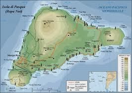 |
| Map of Easter Island using moai to show locations of various ahu /Wikipedia |
The statues were carved by the Polynesian colonizers
of the island, mostly between circa 1250 CE and
1500 CE. In addition to representing deceased ancestors,
the moai, once they were erected on ahu, may also have been regarded as the
embodiment of powerful living or former chiefs and important lineage status
symbols.Each moai presented a status “the larger the statue placed upon an ahu,
the more mana the chief who commissioned it had." The competition for
grandest statue was ever prevalent in the culture of the Easter Islanders. The
proof stems from the varying sizes of moai.
Completed statues were moved to ahu mostly on the coast,
then erected, sometimes with red stone cylinders (pukao) on their heads. moai
must have been extremely expensive to craft and transport; not only would the
actual carving of each statue require effort and resources, but the finished
product was then hauled to its final location and erected.
The quarries in Rano Raraku appear to have been abandoned
abruptly, with a litter of stone tools, many completed moai outside the quarry
awaiting transport and almost as many incomplete statues still in
situ as were installed on ahu. In the nineteenth century, this led to
conjecture that the island was the remnant of a sunken continent and that most completed
moai were under the sea. That idea has long been debunked, and now it is
understood that:
- Some statues were rock carvings and never intended to be completed.
- Some were incomplete because, when inclusions were encountered, the carvers would abandon a partial statue and start a new one (tuff is a soft rock with occasional lumps of much harder rock included in it).
- Some completed statues at Rano Raraku were placed there permanently and not parked temporarily awaiting removal.
- Some were indeed incomplete when the statue-building era came to an end.
Craftsmen
The moai were either carved by a distinguished class of
professional carvers who were comparable in status to high-ranking members of
other Polynesian craft guilds, or, alternatively, by members of each clan. The
oral histories show that the Rano Raraku quarry
was subdivided into different territories for each clan.
Transportation
Since the island was treeless by the time the Europeans
first visited, the movement of the statues was a mystery for a long time;
pollen analysis has now established that the island was almost totally forested
until 1200 CE. The tree pollen disappeared from the record by 1650, and
the statues stopped being made around that time.
It is not known exactly how the moai were moved across the
island, but the process almost certainly required human energy, ropes, and
possibly wooden sledges (sleds) and/or rollers, as well as leveled tracks
across the island (the Easter Island roads). A recent study suggests the
statues might have been harnessed with ropes from two sides and made to
"walk" by tilting them from side to side while pulling forward. They
would also use a chant, whilst 'walking' the moai. Coordination and cohesion
was essential, so they developed a chant in which the rhythm helped them pull
at the precise moment necessary. However, this opinion has come under
debate recently. Another theory suggests that the moai were placed on top
of logs and were rolled to their destinations. If that theory is correct
it would take 50-150 people to move the moai.
Oral histories recount how various people used
divine power to command the statues to walk. The earliest accounts say a king
named Tuu Ku Ihu moved them with the help of the god Makemake, while later stories tell of a woman
who lived alone on the mountain ordering them about at her will. Scholars
currently support the theory that the main method was that the moai were
"walked" upright (some assume by a rocking process), as laying it
prone on a sledge (the method used by the Easter Islanders to move stone in the
1860s) would have required an estimated 1500 people to move the largest moai
that had been successfully erected. In 1998, Jo Anne Van Tilburg suggested fewer than
half that number could do it by placing the sledge on lubricated rollers. In
1999, she supervised an experiment to move a nine-ton moai. They attempted to
load a replica on a sledge built in the shape of an A frame that was
placed on rollers. A total of 60 people pulled on several ropes in two attempts
to tow the moai. The first attempt failed when the rollers jammed up. The
second attempt succeeded when they embedded tracks in the ground. This was on
flat ground and used Eucalyptus wood rather than the native palm trees that
would have lived on the island.
 |
| Sign indicating the protected status of the moai /Wikipedia |
In 1986, Pavel Pavel, Thor
Heyerdahl and the Kon
Tiki Museum experimented with a five-ton moai and a nine-ton moai. With a
rope around the head of the statue and another around the base, using eight
workers for the smaller statue and 16 for the larger, they "walked"
the moai forward by swiveling and rocking it from side to side; however, the
experiment was ended early due to damage to the statue bases from chipping.
Despite the early end to the experiment, Thor Heyerdahl estimated that this
method for a 20-ton statue over Easter Island terrain would allow 320 feet
(100 m) per day. Other scholars concluded that it was probably not the way
the moai were moved due to the reported damage to the base caused by the
"shuffling" motion.
Around the same time, archaeologist Charles Love experimented
with a 10-ton replica. His first experiment found rocking the statue to walk it
was too unstable over more than a few hundred yards. He then found that placing
the statue upright on two sled runners atop log rollers, 25 men were able to
move the statue 150 feet (46 m) in two minutes. In 2003, further research
indicated this method could explain supposedly regularly spaced post holes (his
research on this claim has not yet been published) where the statues were moved
over rough ground. He suggested the holes contained upright posts on either
side of the path so that as the statue passed between them, they were used as
cantilevers for poles to help push the statue up a slope without the
requirement of extra people pulling on the ropes and similarly to slow it on
the downward slope. The poles could also act as a brake when needed.
Based on detailed studies of the statues found along
prehistoric roads, archaeologists Terry Hunt and Carl Lipo have shown that the
pattern of breakage, form and position of statues is consistent with an
"upright" hypothesis for transportation. Hunt and Lipo argue
that the statues found along the road have a center of mass that causes the
statue to fall forward. As the statue tilts forward it rocks on its front edge
and takes a "step." Archaeologically, large flakes are seen broken
off of the sides of the bases. This pattern is consistent with immense forces
being applied to the edges of the statue. On the landscape, road statues are
found on their backs when the road is going uphill and on their front when
going downhill. All of this evidence points to an upright transportation
practice.
Recent experimental recreations have proven that it is fully
possible that the moai were literally walked from their quarries to their final
positions by ingenious use of ropes. Teams of workers would have worked to rock
the moai back and forth, creating the walking motion and holding the moai
upright. If correct, it can be inferred that the fallen road moai were the
result of the teams of balancers being unable to keep the statue upright, and
it was presumably not possible to lift the statues again once knocked over. (Wikipedia)


Comments
Post a Comment